
Visit Florence
- Art & culture
- Tastings & Cooking Classes
- Florence Outdoor
- Day tours
- Events
- Shopping
- Hotels in Florence
Be.Curious
Destination Florence

English

Log in
Sign in


What you will find
The excursion proposal aims to introduce the surroundings of Florence, which are extremely interesting both for the landscape-naturalistic aspect and for the artistic aspect and for the historical connotations. The entire route of the Renaissance Ring stretches for about 250 kilometers, within everyone's reach, suitable for walking or mountain biking; in the planning phase the stretches of the ancient Florentine road network, now obsolete and abandoned, have been identified, avoiding the paved roads with few exceptions.
A vertical and horizontal signage accompanies and guides the hiker.
Each section, if traveled separately, offers the possibility of reaching Florence thanks to connections with public transport.
THE STAGEs OF THE PATH
- CALENZANO - VAGLIA, a very suggestive stretch from a naturalistic point of view, in particular when you are near Monte Morello (19.7 km / 6.40h)).
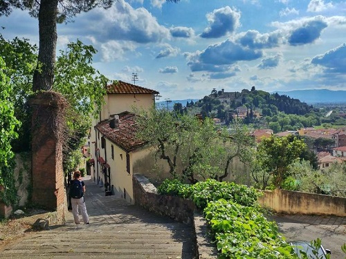
- VAGLIA -ALBERACCIO-FIESOLE, with splendid views of Florence and Fiesole itself (23 km / 6.40h). The Vaglia-Alberaccio-Santa Brigida variant, instead, will take us to know the Convent of Montesenario, the Sanctuary of the Madonna del Sasso, up to Poggio Ripaghera, a place that holds a rare floristic endemism (17.5 km / 3h).
- SANTA BRIGIDA - PONTASSIEVE (13 km / 4h), an incomparable route to relax in the Tuscan countryside, among farmhouses, vineyards and mills.
- PONTASSIEVE - MONTECUCCO - SAN DONATO (13 km / 4.30h), with the Valdarno epicenter of the path. From here, tourists can go along the route which, from Rignano Sull'Arno, leads to Bagno a Ripoli passing through Montecucco (13.5 km / 4h). In this stretch you will walk, ideally, in the footsteps of the pilgrims who once traveled these lands to reach the Rome of the Popes.
- SAN DONATO IN COLLINA - IMPRUNETA (18 km / 6h) is famous for its woods (Fonte Santa), for its vineyards and olive groves, scattered in a landscape dominated by green hills.
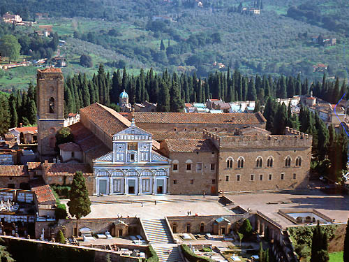
- IMPRUNETA - LA CERTOSA, where it will be possible to visit the monumental complex of the same name (7 km / 2h).
- LA CERTOSA - FLORENCE, arriving at Piazzale Michelangelo (6 km / 2h). On the other hand, the variant La Certosa-Pian dei Cerri-Lastra a Signa-Signa (23 km / 6.30h) lets you know the Bottai valley floor, the hills bordering the Chianti, the Roveta woods and the countryside that he almost seems to dive into the Arno. The Signa-Florence section (12.6 km / 3h) allows, instead, to observe the Renai Park and the Cascine Park, while the Signa-Campi Bisenzio-Calenzano director (16.8 km / 4.30h) has as its protagonist all the Florentine plain.
Walking in the hills, in the woods, at the edge of the cultivated fields, you cross areas of particular landscape importance, cross monasteries, castles, hospitals destined to welcome pilgrims, ancient walled centers, country churches, stretches of paved roads dating back to the Roman period or medieval: ideally one always has a look at the historical center of the city of the flower, whose fulcrum is the Dome of the Cathedral, the work of Filippo Brunelleschi that identifies Florence.
Where / Meeting point
Calenzano - 50041 Calenzano (FI)

 All the services are provided by local merchants
 By using this site you support Florence
 We offer products with high-quality standards
 You stay sustainable
 It's a 100% trustworthy website